
Resource base
Climate
- The territory has a moderately humid and warm climate with plenty of sunshine, especially in summer and autumn. Cloudy days are relatively rare, mostly occurring in winter. Precipitation is minimal, humidity is moderate, and atmospheric pressure remains fairly stable.
- Seaside climate is characterized by mild winters, a long period without frost, and hot, humid summers.
- The average annual air temperature is +13.3 ∞C. The warmest period is from mid-June to late August, with an average temperature of +24 ∞C. During this time, the highest temperatures of 35Ц38 ∞C are recorded. January is the coldest month, with an average temperature of -3.9 ∞C and a minimum of -18 ∞C.
Mineral
resources


Fresh water
reserves
- A local landmark called Natasha Spring. Located to the north-west of the settlement of Mikhailovsky Pass.
Fertile
lands
- The agricultural lands cover an area of 6,689.14 hectares, accounting for 5.46% of the total land area.
Recreational resources
- Gelendzhik city-resort has abundant natural resources and recreational opportunities, mainly used for health treatments and leisure activities. The region has unique natural characteristics that make it attractive for educational tourism.
- The territory of Gelendzhik city-resort, located on the Black Sea coast and the southern slope of the Main Caucasus Range, has abundant recreational opportunities and unique natural resources, such as:
- The region enjoys pleasant weather conditions with temperatures consistently above 15∞C for over 100 days. There are numerous sunny days throughout the year (280 days). The fresh sea air is beneficial, containing high levels of ozone and iodine. Visitors can relax by the Black Sea waters, Gelendzhik Bay, beaches, and promenades. The swimming season typically lasts from late May to October.
- The area has hydro-mineral resources such as mineral waters used for healing and spa purposes, rich forests, a variety of plant and animal species in coastal and mountain regions, the natural park УMarkotkh,Ф geological and botanical landmarks, and mountain rivers, streams, and waterfalls.
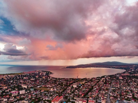
Gelendzhik Bay
It is a shallow bay that has miraculously beautiful shape of a horseshoe, made up of two capes: Thick (Tolstyi) Cape, which is high and rocky, and Thin (Tonkiy) Cape, which is flat and sandy.
The Thin cape is not just referred to as the cape itself, but also the extensive area on the northwestern side of the bay.
The Thin cape is also known as Solntsedar. It got this name because it has more sunshine compared to Gelendzhik, located on the opposite side of the bay, at the foot of the ridge.
The bay is a regular oval with semi-axes measuring 3.8 by 2.8 kilometers.
The bay is quite shallow, with an average depth of around 10 meters in the central area and a maximum depth of 17 meters. The coastline extends for 12 kilometers, including 8 kilometers of both natural and man-made beaches.
The coastal area from Gelendzhik to Inal Bay, which marks the approximate boundary of the city district, still retains its natural wilderness and beauty. The region is mostly covered by untouched and dense forests, with many parts of the coastline being nearly inaccessible due to steep cliffs that drop into the sea. Unlike other areas, the coast here is not deeply indented, but there are small open bays with irregular shapes at the mouths of rivers like Mezyb, Dzhankhot, Vulan, Inal, and Betta. The banks between the rivers have slightly angular shapes. Along the coast, there are occasional rocky outcrops mixed with flat areas forming wide arcs or slightly angular shapes. The Gelendzhik resorts are situated at the mouths of rivers such as Divnomorskoye, Dzhankhot, Krinitsa, Betta, and Arkhipo-Osipovka.
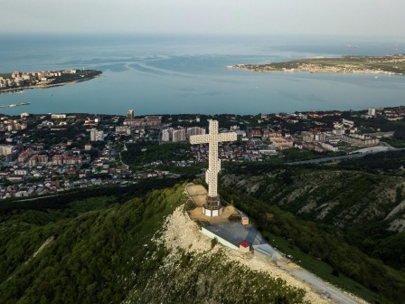
Markotkhsky Ridge
The name translates from Adygean as Уobi Ч new (or berry) mountain.Ф
This name is not accidental, as in the past, this area used to have plenty of dense blackberry and raspberry bushes.
The ridge stretches for 90 km from the Bakanka river in the northwest to the Mezyb river in the southeast. It reaches a maximum height of 800 m, with an average elevation of 500 m above sea level. Some of the notable peaks include Ploskaya (762 m), Sovkhoznaya (717 m), and Sakharnaya Golova (556 m). The Markotkhsky ridge features several accessible passes like Kabardinsky, Markotkh, and Andreyevsky, providing routes to the Neberdzhaevskoye reservoir, the Sheskharis oil base, and the Adegoi river valley. Comprised mainly of thick layers of sedimentary rocks from the Cretaceous period, the ridge's primary rock is marl, a crucial material for cement production. Sandstones, limestones, and clay are also present but less common.
Currently, on the southwestern slope, there are shrub thickets like Christ's-thorn, hawthorn, barberry, and hornbeam, along with a sparse juniper forest that is heavily shaped by the northeastern wind.
Crimean pine, Pizund pine, and oak trees have been planted on this slope since 1948. Broad-leaved forests grow on the northeastern slope.
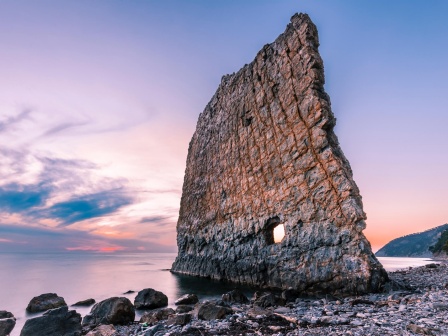
Sail Rock
Sail Rock (УParusФ in Russian) is a natural monument in Krasnodar region, situated on the Black Sea shore, 17 km southeast of Gelendzhik, close to the village of Praskoveyevka (approximately 500 meters along the seashore) and the Dzhankhot khutor (farm) (4.5 kilometers away).
The rock stands vertically on the seashore, separate from the main rock massif by a cavity. Its shape resembles a four-cornered sail, hence its name. The cliff is over 25 meters high, around 20 meters long (some sources mention 30 meters high and 25 meters long), and more than three-quarters of it extends into the sea at a right angle to the shore.
The surrounding area is known for its clean sea water.
An opening of unclear origin is located at the lower part of the rock. Initially, it was believed that the formation was a defence against mountain artillery during the Caucasian War of 1817Ц1864. However, this theory was debunked when, in the early 20th century, four shells were fired from a battleship at the rock, resulting in only minor notches without causing any significant damage.
The unique formation appeared due to the sea encroaching on the land, erosion, and variations in the strength of rock formations.
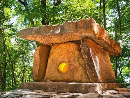
Dolmens
Dolmens are ancient burial structures constructed from large boulders and stone slabs. These tombs are found across Eurasia, including Krasnodar region. Near Gelendzhik, you can discover dolmens of various sizes, with individual slabs weighing up to 40 tons. The precise and impressive craftsmanship is evident in the uniform shape of each stone, resembling factory work rather than the limited tools available to people 3-6 thousand years ago. Most dolmens were built during this period and have remarkably survived to the present day. Primarily used as burial chambers, some of these structures also served as places of worship for various ancient religious groups. While we have identified the coordinates of some popular dolmens, there are many more scattered around the Gelendzhik area.
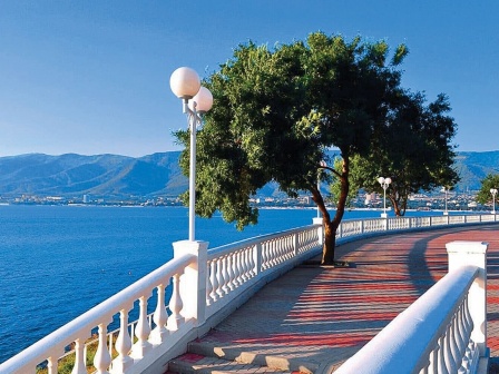
Gelendzhik Embankment
Exploring Gelendzhik typically starts with its main attraction, the embankment, the heart of the resort's life. This well-kept and beautifully designed promenade is a magnet for both visitors and locals, who fondly refer to it as Уsnow-whiteФ due to its predominantly white color scheme. The Gelendzhik embankment holds the record for being the longest in Russia, stretching over 12 kilometers. Within this extensive area, there are numerous attractions, cafes, restaurants, playgrounds, parks, and everything else a tourist might need. The embankment is always bustling with people, but the liveliest section is Lermontov Boulevard, known for its sanatoriums, viewpoints, and iconic sculptures like Assol and White Bride. The atmosphere along GelendzhikТs promenade is perpetually festive, with breathtaking views of the sea, mountains, and charming yachts that beckon to be captured in photos.